Notes
- GPS in a Vehicle
- What are we doing? Requires Adobe reader.
Experiments
|
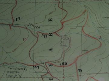
I have posted on this site, photos, GPS tracks, logs and maps of some of our Saturday wandering around trips and explorations. On these trips, my companions and I, take pictures while running all over the place with the GPS. Afterwards we print out maps to see where we REALLY went instead of where the out-of-date maps show the roads going. U.S. Forest Service road 183 in the image on the right is an example of this. The map doesn't even show the road. I have posted most of my files either as a Delorme file of some sort or as text. If you need the data in a different format than what I have provided, go on the internet and find GPSBABEL which is a free program that converts between different GPS formats. As time permits, more information will become available along with some of the programs I have written to make the GPS information as useful as possible.
Do you have some comments and questions? |
 |